Squamish

Photo by Davide Tortora | Flickr
- Name: Stawamus Chief
- Difficulty: Intermediate
- Time: 6 hours
- Round Trip: 11km
- Elevation gain: 600m
- Best time of the year: March-November
- Distance from Vancouver: 1 hour/ 62 km
The Chief towers high above the town of Squamish and is a popular hiking destination that offers scenic views of Howe Sound and several mountains in Garibaldi Provincial Park. Hikers can complete all three peaks of the Chief in a day or just choose to do a shorter trip to the South Peak that still offers a spectacular view. While not overly technical, the Chief is nonetheless a challenging hike, mainly because it doesn’t beat around the bush. Easy access and rewarding views of Howe Sound make this a must-do hike.

Photo by Duncan Sadava
- Name: Four lakes trail
- Difficulty: Easy
- Time: 2 hours
- Round Trip: 6km
- Elevation gain: 198 m
- Best time of the year: April-November
- Distance from Vancouver: 1 hour 20 minutes/ 75km
Alice Lake is one of Squamish's sweet spots, surrounded by towering mountains, dense forests and grassy areas. The 4 Lakes Trail is an easy 6 km loop that meanders through creeks, second growth forest and visits four distinct mountain lakes and groves of Cedar, Hemlock, and Douglas fir trees. These lakes are not just for your hiking pleasure; you can try your luck at fishing (with a the proper licences) and take a refreshing swim along the way. The four lakes trail is a local favourite hike located in Alice Lake Provincial Park. Compared to other Squamish hiking trails, Four Lakes is very easy and relaxing. No serious hiking here, but rather walking, talking and enjoying the beautiful forest and lakes along the trail.
Golden Ears Provincial Park

Photo by mananetwork /Flickr
- Name: Golden Ears West Canyon Trail
- Difficulty: Difficult
- Time: 12 hours
- Round Trip: 24 km
- Elevation gain: 1500m
- Best time of the year: July-September
- Distance from Vancouver: 1 hour 20 minutes/ 60km
The Golden Ears Trail is a popular hike in Golden Ears Provincial Park and offers some spectacular views for those who accomplish this challenging trail. It can be completed in a day but many people also choose to camp overnight at the Alder Flats campsite while hiking this trail. The park is a beautiful place, the trail meanders along beautiful Golden Creek until you reach the point where you start across the alder flats and up towards panorama ridge. A great location for anyone who wants to really get a taste of what the North Shore Mountains have to offer without driving for hours.
- Name: Gold Creek Falls
- Difficulty: easy
- Time: 2 hours
- Round Trip: 5.5 km
- Elevation gain: minimal
- Best time of the year: Year round
- Distance from Vancouver: 1 hour 30 minutes/ 65km
One of the easier hikes to do in Golden Ears Provincial Park is the Lower Falls Trail along Gold Creek. The trailhead is easy to find at the northwest end of the parking lot. This hike is only 5.5km (round trip) and has minimal elevation change which makes it much more accessible than some of the other hiking trails in Golden Ears Park. The view of the falls from above can be fantastic, particularly in the spring season when the runoff from the surrounding mountains is surging downstream. After taking in the view in the mist from the falls, continue up the trail to the next viewpoint at the top of the falls, and then follow the trail back to the parking lot.
Garibaldi Provincial Park

Photo by Junichi Ishito /Flickr
- Name: Cheakamus Lake
- Difficulty: easy
- Time: 5 hours
- Round Trip: 16 km
- Elevation gain: minimal
- Best time of the year: May-November
- Distance from Vancouver: 2 hours 15 minutes 99 km
One of the easier hikes in Garibaldi Provincial Park, Cheakamus Lake offers beautiful views of a turquoise lake surrounded by towering mountains and lush forests. The trail to Cheakamus Lake takes you through an amazing forest of giant cedars. This forest is so packed with ancient giants that year to year the trail is adjusted by a monster of a tree fallen across the trail during some winter storm.
The trail hugs the edge of the lake, with frequent views of its amazing, turquoise colour, distant snow capped mountains and occasional bear sightings. With so much to see and such an enjoyable trail, Cheakamus Lake one of Whistler's best and most family friendly hikes. The trail is never strenuous and constantly beautiful with the wonderful smells that come with an old growth cedar forest are incredible.
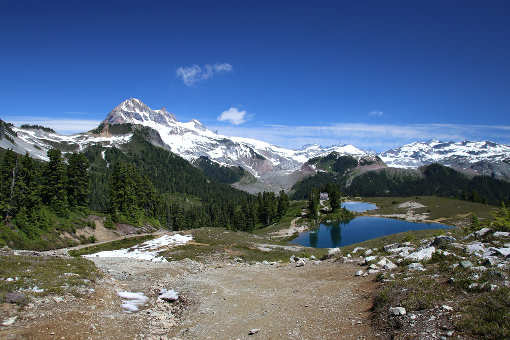
Photo by Explore Squamish
- Name: Elfin Lakes
- Difficulty: Intermediate
- Time: 6 hours
- Round Trip: 22km
- Elevation gain: 600m
- Best time of the year: July-October
- Distance from Vancouver: 1 hour 45 minutes/ 85km
Elfin Lakes are two small lakes located in the scenic alpine setting of Garibaldi Provincial Park near Squamish, British Columbia. The hike towards Elfin Lakes is a great adventure into the backcountry of British Columbia, which provides a full day of hiking without being overly strenuous. Amazing scenery and the ability to take a dip in the lake make this a must-do summertime hike. People are allowed to swim in the top lake, however the lower lake is reserved for drinking water only and must be kept clean. After a full day of hiking there is the option to stay overnight in a heated hut, which is also used by hikes who plan on hiking further the next day towards Opal Cone, the Gargoyles, or Mamquam Lake, for example.
The North Shore

Photo by Live Dream Discover
- Name: Bowen Lookout
- Difficulty: easy
- Time: 1.5 hours
- Round Trip: 4 km
- Elevation gain: 110m
- Best time of the year: July-October
- Distance from Vancouver: 30 minutes/ 28km
The Bowen Lookout is another spectacular trail that is short but offers spectacular views of the Sunshine Coast and Bowen Island on a clear day. The trail itself is located in the BC Parks area of Cypress Mountain. The hike is relatively short, with a steep climb and is often done as a short side-trip on the way to St Mark's Summit. It is a well-marked trail that passes through some beautiful old growth forest and meadows. Friendly Whiskey Jacks and Blue Jays frequently visit the lookout point hoping to join in on your picnic. In the winter the Bowen Lookout trail turns into an easy snowshoeing trail.

Photo by Carmen Braun
- Name: St Marks summit
- Difficulty: Intermediate
- Time: 5 hours
- Round Trip: 11 km
- Elevation gain: 460m
- Best time of the year: July-October
- Distance from Vancouver: 30 minutes/ 28 km
St. Mark’s Summit is a peak along the Howe Sound Crest Trail that spans over 30km from the Cypress ski resort to a point along the Sea to Sky Highway near Porteau Cove. Heading to Saint Mark’s Summit is a worthy destination of its own and can be done in about 4 to 5 hours. From the peak you can see the islands of Howe Sound, the Tantalus Range and even Vancouver Island. There are a few other viewpoints along the short ridge that are worth checking out before making your journey back towards Cypress Mountain. The trail that St. Mark's Summit is on starts from Cypress Mountain ski resort, which offers spectacular views of Howe Sound on a clear day.

Photo by Into The Wild
- Name: Baden powell Deep Cove to Lynn Canyon
- Difficulty: Intermediate
- Time: 5 hours
- One way: 12 km
- Elevation gain: 420m
- Best time of the year: Year round
- Distance from Vancouver: 30 minutes/ 20km
The Baden Powell Trail is one of the most well known trails in North Vancouver. It crosses the entire North Shore mountain range and links several parks together along the way. This eastern section of the 48km long Baden Powell trail travels from Deep Cove to the Lynn Valley Suspension Bridge.
The first section of the trail is known by the locals as Quarry Rock, a short hiking trail that takes you to a large rock with a view of the entire Deep Cove and Indian Arm area.
The second part of the trail passes several scenic landscapes and great canyon scenery of the Seymour River and Lynn Creek. Please note that this hike has a different starting and ending point, so you will need to arrange transportation either back to your car at the starting point or through public transit.

Photo by Simon C.
- Name: Crown Mountain
- Difficulty: Difficult
- Time: 7 hours
- Round Trip: 9.8 km
- Elevation gain: 385m
- Best time of the year: July-October
- Distance from vancouver: 30 minutes/ 15km
The hike to Crown Mountain behind Grouse Mountain is very difficult but on a clear day, you will be rewarded with incredible views of the Capilano Watershed, the Lions, the city of Vancouver in the distance, and many backcountry coastal mountains. The jagged peak, which resembles a crown, towers above several of the other nearby mountains. What makes this trail so difficult is you have to hike down a very steep trail into Crown Pass before hiking up the steep side of Crown Mountain, and then return the same route.
The trail to Crown Mountain is located in Lynn Headwaters Regional Park and is best started at the Alpine Trail behind Grouse Mountain by taking the Grouse Mountain gondola to the top. Ambitious hikers can also take the Grouse Grind, BCMC Trail, or Hanes Valley route but adding these routes onto the Crown Mountain trail will make for a very long, strenuous day.